Activity
Hiking & Trekking
Spread the word


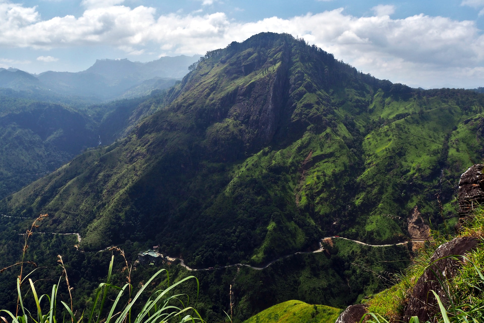
- Keselpaddoruwa hiking and trekking
Kesel Paddora is a beautiful Mountain Range famous for hiking and climbing. This is a hidden paradise which belongs to the Uda dumbara division in Central Province of the country. Due to the elevation of 324m above sea level, the weather will be relatively warm. For this region, the rainy season runs from November through February. The best time to visit is between May and September, when there is typically little rain. A hike to this mountain, which has risen above 1,529 meters above sea level, is indeed a hard and challenging task, given its blurred weather and trail paths. The attempt is worth the effort, and the scenic view from the summit is stunning. There are beautiful and unique floras that you could observe while climbing up. From the summit, the views of Yahangala, Gombaniya, Lakegala, Thunhisgala, Randenigala Dam, Rantambe Dam are so delightful. Even the village of Mahiyanganaya is so clear from the top.
Accomadation- yahangala Resort
Transportation- Bike,Taxi,Public transport
Necessary items- carry enough water
Use leach repellent
- CORBETT’S GAP
Corbett’s Gap is one of the highest mountain passes in Sri Lanka named after British Army colonel, naturalist and adventurer, Jim Corbett. The hike is mostly along an abandoned jeep track that cuts through the Knuckles Conservation Forest an UNESCO designated World Heritage Site. These montane cloud forests, where the land rises to 2,500 metres above sea level, are home to an extraordinary range of flora and fauna, including several endangered species such as the westernpurple-faced langur, the Horton Plains slender loris and the Sri Lankan leopard. This trip begins with an hours drive through stunning mountain vistas, verdant tea fields and daily life of a very rural local village nestled in the foothills of the mountains. Soon you enter a thick lush cloud forest canopy heavy with mist and dew and reach Corbett’s Gap with its panoramic breath-taking views.
Duration: 10kms /4.5 hours.
Essentials: Long bottoms, trainers/ walking boots, backpack.
Facilities: toilet tent and the sleeping tents
Accomoation: Corbet's Bungalow
Transport: Public & private vehicles
- Narangamuwa across laggala pallegama mountain trekking
Narangamuwa Lakegala Mountain is a popular hiking area situated in Matale. It consists of two peaks namely Meemure Lakegala and Narangamuwa Lakegala. Meemure Lakegala is a dangerous hike which requires much hiking skills. Lakegala Mountain is about 1310 meters high and its name translates to “The Rock of Lanka”. It is known to be among the hardest hikes in Sri Lanka. Lakegala Mountain is situated within the Knuckles Mountain Range. Although challenging, it is one of the best hiking spots in Sri Lanka.
Have a guide from the village with you and do not attempt to hike the mountain on your own.
Avoid hiking the mountain during the rainy season. (August and September are the best for hiking Lakegala)
Take appropriate mountain climbing gear, equipment and ample amounts of food and water - Dothalugala
The Dothalugala Nature trail also starts near the information center (have to walk towards meemure for another 500m and you will see the starting point to get to the nature trail.) The dothalugala nature trail is about 5km walk and you will see amazing scenes and rare species of animals, plants, birds and lizards. (I was lucky enough to capture a Sri Lankan rough horn lizard in this trail)
Transportation mode- Personal transport
Parking facilities available and single ticket to both Deanston Mini World’s End and Dothalugala
*Two cement platform to a camping
*Water and equipments, foods and leach protection should bring
*trekking duration is 4 hour
Parking facilities available near the Deanston Conservation Center.
- Hiking & trekking in Knuckles Mountain range
The Knuckles Mountain Range lies in central Sri Lanka, in the Districts of Matale and Kandy. The range takes its name from a series of recumbent folds and peaks in the west of the massif which resembles the knuckles of clenched fist when viewed from certain locations in the Kandy District.
Whilst this name was assigned by early British surveyors, the Sinhalese residents have traditionally referred to the area as Dumbara Kanduvetiya meaning mist-laden mountain range. Knuckles Mountain Forest Range covering an area of approximately 21,000 ha is a part of the Central Highlands World Heritage site, declared in 2010.
Though it is a part of Central Highlands it is well separated by Mahaweli river valley from the sides of South and east and Matale valley from the west.Knuckles Mountain Forest Range consists of a range of vegetation types that have resulted from diverse climatic and topographic conditions.
Among these are the humid tropical lowland semi evergreen forest, tropical sub-montane humid evergreen forest, montane grassland (patana) and pygmy forest.
The complexity brought to the area with vegetation types is further increased by range of modifications made to the landscape by people since the British colonization.
Knuckles Mountain Forest Range supports a rich biological diversity with 128 species of birds, 20 species of amphibians, 53 species of reptiles, 15 fresh water species and 31 mammal species. All species are not equally distributed throughout the range. Their distribution depends on multiple factors such as food availability, availability of nesting sites etc. that vary with climate, elevation and land cover. - Hiking/trekking to Kirigalpoththa Mountain via Horton Plains. Kirigalpoththa is the 2nd highest Mountain of Sri Lanka after Pidurutalagala. With a peak elevation of 2,388 meters above sea level. Kirigalpoththa is the highest point in the Horton Plains National Park and also the highest peak accessible to the public. This 7 K.M trail (one way) will take around 5 1/2 hours of trekking, hiking & mountaineering challenges.
Attempting Kirigalpoththa is for the daring adventurers only as the conditions can be treacherous due to the difficulty of the terrain and weather. For every eight people who have reached the summit, one has always never reached the summit.
A single & a slightly over grown path snake through grassy plains, cloud forest, bog & finally steep rock surfaces. Sri Lankan Leopard & Sambur are the bigger wild animals you may sometimes come across; if you are lucky, you may even encounter a few endemic bird species as well. Horton Plains National Park in Pattipola is a protected area in the central highlands of Sri Lanka and is covered by montane grassland and cloud forest.
This plateau at an altitude of 2,100– 2,300 meters (6,900–7,500 ft.) is rich in biodiversity and many species found here are endemic to the region. This region was designated a national park in 1988. It is also a popular tourist destination and is situated 8 kilometers (5.0 mi) from Ohiya, 6 kilometers (3.7 mi) from the world famous Ohiya Gap/Dondra Watch and 32 kilometers (20 mi) from Nuwara Eliya.
The Horton Plains are the headwaters of three major Sri Lankan rivers, the Mahaweli, Kelani, and Walawe. In Sinhala the plains are known as Maha Eliya Plains. Stone tools dating back to Balangoda culture have been found here. The plains' vegetation is grasslands interspersed with montane forest, and includes many endemic woody plants.
Large herds of Sri Lankan Sāmbhar deer feature as typical mammals, and the park is also an Important Bird Area with many species not only endemic to Sri Lanka but restricted to the Horton Plains. Forest dieback is one of the major threats to the park and some studies suggest that it is caused by a natural phenomenon. Horton Plains is located on the southern plateau of the central highlands of Sri Lanka.
The peaks of Kirigalpoththa (2,388 meters (7,838 ft.)) and Thotupola Kanda (2,357 meters (7,733 ft.)), the second and the third highest of Sri Lanka, are situated to the west and north respectively. The park's elevation ranges from 2,100–2,300 meters (6,900–7,500 ft.). The rocks found in the park belong to the Archaean age and belong to the high series of the Precambrian era and are made up of Khondalites, Charnockites and granitic gneisses. The soil type is of the red-yellow podzolic group and the surface layer is covered with decayed organic matter. - Trekking to Kondagala peak via Loolecondera tea estate – First commercial tea estate in Sri Lanka Kondagala is a scenic mountain peak located above the first commercial tea estate called Loolecondera. Hikers can reach Kondagala peak via Kandy Deltota Road. Once you pass Deltota town you need to take the Hewaheta road to reach the Loolecondera Tea Estate, then you can start the hike via the estate. Kondagala peak is one of the few places in Sri Lanka which provide a majestic 360 degree view of the surroundings.
On a clear day you can see some breath-taking views of the Knuckles mountain range, Hantana Range, Alagalla peak, Ambuluwawa, Single tree hill and Adams peak from the top of Kondagala. Hikers need to be mindful when you are on top of Kondagala because of the rocky surface, 90-degree edge and the sudden mist...
- Loolecondera Tea Estate
Loolecondera Estate in the Kandy district is the very first patch of tea was planted as a test after the failure of coffee plantation in Sri Lanka. With the wild success of this plantation, then 21 year old planter James Taylor who was in charge of this plantation has been forever immortalized and has become a part of post colonization history of Sri Lanka.
Here you can see the Taylor’s Seat, a rock seat used by James Taylor which gives a fantastic view of the surrounding mountain ranges, The chimney of the log cabin which was used by Taylor (only remaining part of the cabin), The well-used by Taylor and the very first patch of tea which was planted by Taylor now known as the No.7 field of the Loolkandura (Loolecondera) Estate. One unique decision of James Taylor is the naming of the estate. When all other planters who setup estates named them with English names close to their hearts Taylor named his estate “Loolecondera”, by the local name of the area Loolkandura as he spelled it - Hiking & trekking to Kota Ganga waterfall in Knuckles Mountain range The Kota Ganga Ella Falls (Kota Ganga Ella) is a cluster of cascading waterfalls on Knuckles Mountain Range in the Kandy District. The cluster consists of at-least 7 major segments totaling probably over 100 meters in height. The cluster of waterfalls lies deep inside the jungle with no established trail and other trails known by the villagers. Also there is no full view point for this waterfall. Trekkers can reach this waterfall from Thangappuwa village. The hike is approx. 5.5km uphill walk. It’s highly recommended to go with a guide who knows the directions well to
the fall.
- Riverstone day excursion Located approximately 30 km from the Matale town, when travelling on Matale – Laggala- Pallegama road, rather windy with quite a few hairpins turns but in good condition, offers great views all around with a mini worlds end, lot less travelled by main stream tourists.
Climatic conditions here are very similar to Horton plains with the addition of having two great waterfalls “Sera Ella” and “Bambarakiri Ella”, both of which are a site for sore eyes, don’t forget to relax on the rock seats of “Sera Ella” relishing the cold misty spray of water on your face and Thelgamu Oya offers a great site for a dip in crystal clear but chilly water.
Travelling further upstream on this very scenic stream will no doubt will make you feel refreshed and rejuvenated. We recommend that you plan a trekking trip (02.5km) to the mist clad Riverston peak via pittawala pathana, as it offers some of the greatest views of the central hills across the mini worlds end which ends in a sheer drop of 300 meters offering a great vista especially of the “Knuckles range”, and the thelgamu valley below with its terraced paddy field method unique to the central hills of Sri Lanka.
- Trekking to Heeloya Village – Exploring typical Sri Lankan Village lifestyle Heeloya is a rural, remote agricultural village in the Kandy district with a unique attraction of understanding how justice was meted out in the good old days. The proceedings of hearing a case by the village-headman and the location are still intact. The main livelihood of the village community is paddy cultivation, home gardening, livestock and spices. Villagers engage in toddy tapping, handicrafts, bee-keeping, traditional dances etc., as supplementary income sources.
A very traditional village, it is unique in that it identifies itself with practicing even to this day some of the local customs in daily life. Tourists are encouraged to work and become part of the village life by engaging in plucking fruits and vegetables for a meal to be prepared according to the local taste. They would also get an opportunity to watch some of the other aspects of this village being the Heeloya waterfall, local species and herbs. Visitors to Heeloya can get a feel of the life in a typical village in addition to trekking and sight-seeing and a culinary experience in true Sri Lankan style! We offer these tours as half day or full day excursions.
-
Trekking to Peacock Hill – Pussellawa Peacock hill Mountain is the highest peak in Pussellawa - Sri Lanka (1513 meters above sea level), rising only 200 meters above the Pussellawa city. Peacock hill is easily accessible by using the roads across the villages. Peacock Hill Mountain is one of the most panoramic vantage points of Pussellawa which gives an extraordinary view of the most mountains and cities around where you could absorb the beauty of Gampola town, Pussellawa town, Ambuluwawa, Dolosbage mountain range, Nawalapitiya town, Nuwara-Eliya town, Pidurutalagala range, Kotmale reservoir & Bible rock. A traveler would have a wonderful time walking up the hill in the midst of the immaculate Pussellawa atmosphere.
-
Trekking to Single Tree Hill - 10th highest peak in Sri Lanka & Shanthipura –Highest Village in Sri Lanka Single Tree hill/One tree hill Mountain is the tenth highest peak in Sri Lanka (2100 meters), rising only 250 meters above the Nuwara Eliya city. Single tree hill is easily accessible by use of the road across the tea estate.
Single Tree Hill Mountain is one of the most panoramic vantage points of Nuwara Eliya which gives an extraordinary view of the city below where you could absorb the beauty of the Haggala Mountain, Pidurutalagala range, Lake Gregory and the whole of the northern slice of the Horton Plains.
A traveller would have a wonderful time walking up the hill in the midst of the immaculate Nuwara Eliya atmosphere; the locals too are very kind and well-mannered people who will help you around the city at any time. Walking through the natural montane forest and a eucalyptus plantation, we will come across a variety of bird species, butterflies, lizards, frogs and a vivid array of wild flowers. Before long, we will reach “Shanthipura”, Sri Lanka’s highest village with an elevation of 2034 meters, where the observation point will provide you yet another bird’s eye view of the Garden City of Nuwara Eliya.
-
Exploring waterfalls in Knuckles Mountain range Sri Lanka, in comparison to its size, has perhaps the largest number of waterfalls of any country in the world. Indeed, there are nearly 500 listed waterfalls. Knuckles Mountain Range stretch across nearly 21,000 ha consists nearly 30 waterfalls in the entire sanctuary. These waterfalls are major water-sources to the longest river in the country which is Mahaweli River. Out of these 30 nearly 15 waterfalls are located bordering the Knuckles range. In this day excursion we are planning to visit 6 -7 waterfalls depending on the ability of clients walking speed and fitness levels.
-
Huluganga falls Height – 50 Meters Approx.
Huluganga Ella Falls (75m in height) is one of many cascades created by the stream originating from the Knuckles Mountain range. The cascading water sprinkles the villages of Elliyadda and Aratthana, before flowing to the Victoria Reservoir. The fall is situated below the town of the Huluganga, near Panwila, (Kandy District, Panwila Provincial Secretariat Division)
-
Jodu Ella falls/Twin Falls Height – 45 Meters
The twin falls of Jodu Ella Falls, also known as ‘Bambarella Knuckles falls’, have identical heights (45m) and cascade simultaneously from both ends of the mountain into the Mahaweli River via the Hulu Ganga River. The Moragaha River is the source, which springs from Me Malai, part of the Knuckles Mountain range. Before reaching the falls, the water flows down seven cascades and through several pools. -
Knuckles falls Height – Approx. – 15 Meters
Knuckles falls located inside the Knuckles Conservation Forest Reserve. Traveler’s need to do a 3 k.m uphill hike to reach the waterfall via tea estates and the forest.
-
Lebanon Estate falls 01 Height – Approx. 30 Meters
the Lebanon Estate in Kandy District hides two large and beautiful waterfalls. These waterfalls are relatively unknown and has no names. The first waterfall lies near the turn off to the Lebanon estate on the Bambarella Road.
A stream originating from the Knuckles Mountain range flows through the estate and crosses the Bambarella Road near this junction. About 250 meters downstream from the bridge, this 30-meter waterfall is formed and the water plunge in to a pool in a straight fall. This waterfall can be reached by traveling 5.5 kilometers from the Huluganga Ella Falls along the Panwila – Bambarella road and need to walk around one kilometer through the tea estate...
-
Lebanon Estate falls 02 Height – Approx. 15-20 Meters This water fall lies deep inside the Lebanon estate village. Traveler’s need to take road towards the estate just before the bridge. It’s an about 1.5 km hike through line rooms and a small jungle patch to reach this waterfall.
-
Saree Ella Falls Height – Approx. 60-65 Meters. Saree Ella lies 5-minute drive from the small village call Bambarella. This waterfall takes form of a fall of a ladies Saree thus its name. The fall consists of number of cascades and can be accessed on any vehicle. Bambarella is one of the popular access points to Knuckles Mountain range and this area is home to number of waterfalls surrounding Hulu Ganga (Hulu River).
-
Thaliya Wetuna Ella falls Height – 50 Meters. this 50-meter high Thaliya Wetuna Ella waterfall lies in Alakola Estate in the Knuckles Mountain range in Kandy District.
Therefore, this fall is also known as Alakola Ella. It is formed in a tributary of the Hulu Ganga originating in the Knuckles Mountain range. The road towards Alakola Estate is situated right in front of the Hulu Ganga Bridge. Travel about 3km along the road and you will find a footpath leading towards to the base pool of the Thaliya Wetuna Ella. Traveler’s need to walk around one and half kilometer’s trough the tea estate to reach the waterfall.
-
-
More things to do